


16 km des 3laçs

cailloux54
User
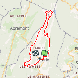

Length
15.3 km

Max alt
993 m

Uphill gradient
502 m
Km-Effort
22 km

Min alt
777 m

Downhill gradient
503 m
Boucle
Yes
Creation date :
2019-10-13 07:23:02.162
Updated on :
2019-10-13 12:11:17.494
4h16
Difficulty : Easy

FREE GPS app for hiking
 SityTrail
IGN / Geographical institutes
SityTrail Plus
The world is yours!
About
Trail Walking of 15.3 km to be discovered at Auvergne-Rhône-Alpes, Ain, Charix. This trail is proposed by cailloux54.
Positioning
Country:
France
Region :
Auvergne-Rhône-Alpes
Department/Province :
Ain
Municipality :
Charix
Location:
Unknown
Start:(Dec)
Start:(UTM)
706982 ; 5117862 (31T) N.
Comments