Les Echelles-2019-09-28

Valmeinier
User
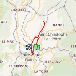

Length
8.6 km

Max alt
712 m

Uphill gradient
349 m
Km-Effort
13.3 km

Min alt
388 m

Downhill gradient
348 m
Boucle
Yes
Creation date :
2019-10-14 09:11:54.745
Updated on :
2019-10-14 09:12:47.186
2h45
Difficulty : Difficult

FREE GPS app for hiking
 SityTrail
IGN / Geographical institutes
SityTrail Plus
The world is yours!
About
Trail Walking of 8.6 km to be discovered at Auvergne-Rhône-Alpes, Savoy, Les Échelles. This trail is proposed by Valmeinier.
Positioning
Country:
France
Region :
Auvergne-Rhône-Alpes
Department/Province :
Savoy
Municipality :
Les Échelles
Location:
Unknown
Start:(Dec)
Start:(UTM)
715453 ; 5035098 (31T) N.
Comments