track

Blourouce
User

Length
5.7 km

Max alt
26 m

Uphill gradient
25 m
Km-Effort
6 km

Min alt
16 m

Downhill gradient
24 m
Boucle
Yes
Creation date :
2019-10-14 14:20:25.628
Updated on :
2019-10-14 14:22:12.468
1h20
Difficulty : Easy

FREE GPS app for hiking
 SityTrail
IGN / Geographical institutes
SityTrail Plus
The world is yours!
About
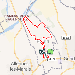
Trail Walking of 5.7 km to be discovered at Hauts-de-France, Nord, Herrin. This trail is proposed by Blourouce.
Positioning
Country:
France
Region :
Hauts-de-France
Department/Province :
Nord
Municipality :
Herrin
Location:
Unknown
Start:(Dec)
Start:(UTM)
497569 ; 5599054 (31U) N.
Comments