


chabrilla'

raygautier
User
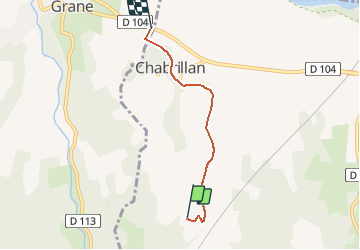

Length
3.7 km

Max alt
232 m

Uphill gradient
37 m
Km-Effort
4.3 km

Min alt
170 m

Downhill gradient
93 m
Boucle
No
Creation date :
2019-10-14 17:58:07.604
Updated on :
2019-10-14 18:06:28.811
7m
Difficulty : Very easy

FREE GPS app for hiking
 SityTrail
IGN / Geographical institutes
SityTrail Plus
The world is yours!
About
Trail Walking of 3.7 km to be discovered at Auvergne-Rhône-Alpes, Drôme, Chabrillan. This trail is proposed by raygautier.
Description
facile
Positioning
Country:
France
Region :
Auvergne-Rhône-Alpes
Department/Province :
Drôme
Municipality :
Chabrillan
Location:
Unknown
Start:(Dec)
Start:(UTM)
654186 ; 4952094 (31T) N.
Comments