


sentier 45

dewaeph
User
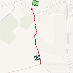

Length
656 m

Max alt
122 m

Uphill gradient
18 m
Km-Effort
839 m

Min alt
102 m

Downhill gradient
1 m
Boucle
No
Creation date :
2019-10-17 08:34:19.164
Updated on :
2019-10-17 08:48:50.511
14m
Difficulty : Very easy

FREE GPS app for hiking
 SityTrail
IGN / Geographical institutes
SityTrail Plus
The world is yours!
About
Trail Walking of 656 m to be discovered at Wallonia, Walloon Brabant, Lasne. This trail is proposed by dewaeph.
Positioning
Country:
Belgium
Region :
Wallonia
Department/Province :
Walloon Brabant
Municipality :
Lasne
Location:
Lasne
Start:(Dec)
Start:(UTM)
602607 ; 5615675 (31U) N.
Comments