


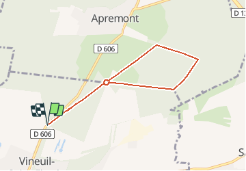
La Table d'Apremont _ 6,7 km

Pousscailleux
User

Length
6.6 km

Max alt
80 m

Uphill gradient
47 m
Km-Effort
7.2 km

Min alt
60 m

Downhill gradient
47 m
Boucle
Yes
Creation date :
2015-03-14 00:00:00.0
Updated on :
2015-03-14 00:00:00.0
1h38
Difficulty : Unknown

FREE GPS app for hiking
 SityTrail
IGN / Geographical institutes
SityTrail Plus
The world is yours!
About
Trail Walking of 6.6 km to be discovered at Hauts-de-France, Oise, Vineuil-Saint-Firmin. This trail is proposed by Pousscailleux.
Description
Départ du carrefour d'Aumale,le long de la D606.
Positioning
Country:
France
Region :
Hauts-de-France
Department/Province :
Oise
Municipality :
Vineuil-Saint-Firmin
Location:
Unknown
Start:(Dec)
Start:(UTM)
463181 ; 5450610 (31U) N.
Comments
De jolies parties de Cricket et de Polo aperçues depuis le parcours !