


Le Chêne à l'Image _ 6,8 km

Pousscailleux
User
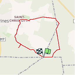

Length
6.8 km

Max alt
182 m

Uphill gradient
115 m
Km-Effort
8.3 km

Min alt
113 m

Downhill gradient
115 m
Boucle
Yes
Creation date :
2014-12-10 00:00:00.0
Updated on :
2014-12-10 00:00:00.0
1h48
Difficulty : Easy

FREE GPS app for hiking
 SityTrail
IGN / Geographical institutes
SityTrail Plus
The world is yours!
About
Trail Walking of 6.8 km to be discovered at Hauts-de-France, Oise, Chamant. This trail is proposed by Pousscailleux.
Description
Départ du parking du Poteau des Blancs Sablons.
Le Chêne à l'Image est un arbre vénéré sur lequel, en haut du tronc, a été installée une reproduction de la Vierge Marie.


Positioning
Country:
France
Region :
Hauts-de-France
Department/Province :
Oise
Municipality :
Chamant
Location:
Unknown
Start:(Dec)
Start:(UTM)
471773 ; 5454834 (31U) N.
Comments