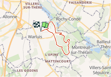
L'ermitage de Saint Arnoult _9,5 km

Pousscailleux
User


2h40
Difficulty : Medium

FREE GPS app for hiking
 SityTrail
IGN / Geographical institutes
SityTrail Plus
The world is yours!
About
Trail Walking of 9.5 km to be discovered at Hauts-de-France, Oise, Warluis. This trail is proposed by Pousscailleux.
Description
Départ du parking du Musée de l'Aviation à Warluis.
Circuit entièrement balisé jaune.
Une fiche "Les Trésors de Warluis" de laquelle a été tiré ce tracé peut être téléchargée sur le site www.oise-randonnée.com.
Positioning
Comments