


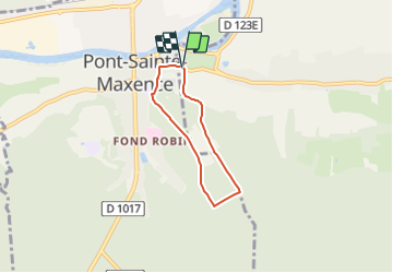
L'Abbaye Royal du Moncel _ 4,2 km

Pousscailleux
User

Length
4.2 km

Max alt
130 m

Uphill gradient
102 m
Km-Effort
5.5 km

Min alt
37 m

Downhill gradient
103 m
Boucle
Yes
Creation date :
2014-12-10 00:00:00.0
Updated on :
2014-12-10 00:00:00.0
1h12
Difficulty : Easy

FREE GPS app for hiking
 SityTrail
IGN / Geographical institutes
SityTrail Plus
The world is yours!
About
Trail Walking of 4.2 km to be discovered at Hauts-de-France, Oise, Pontpoint. This trail is proposed by Pousscailleux.
Description
Départ près de l'entrée de l'Abbaye Royale du Moncel
Positioning
Country:
France
Region :
Hauts-de-France
Department/Province :
Oise
Municipality :
Pontpoint
Location:
Unknown
Start:(Dec)
Start:(UTM)
471798 ; 5461077 (31U) N.
Comments