


La Tête des Filles _ 6 km

Pousscailleux
User

Length
6 km

Max alt
157 m

Uphill gradient
116 m
Km-Effort
7.6 km

Min alt
99 m

Downhill gradient
113 m
Boucle
Yes
Creation date :
2014-12-10 00:00:00.0
Updated on :
2022-11-28 14:34:16.608
1h37
Difficulty : Easy

FREE GPS app for hiking
 SityTrail
IGN / Geographical institutes
SityTrail Plus
The world is yours!
About
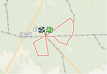
Trail Walking of 6 km to be discovered at Hauts-de-France, Oise, Pont-Sainte-Maxence. This trail is proposed by Pousscailleux.
Description
Départ du carrefour du Grand Maître.
Boucles en 8 en forêt d'Halatte.


Positioning
Country:
France
Region :
Hauts-de-France
Department/Province :
Oise
Municipality :
Pont-Sainte-Maxence
Location:
Unknown
Start:(Dec)
Start:(UTM)
471414 ; 5458383 (31U) N.
Comments