


Le mole

trailer38
User
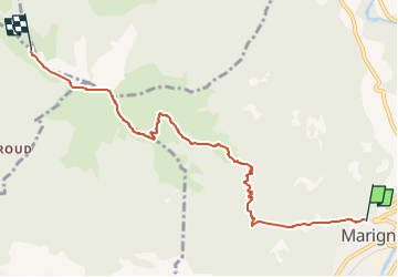

Length
6.4 km

Max alt
1842 m

Uphill gradient
1326 m
Km-Effort
21 km

Min alt
520 m

Downhill gradient
289 m
Boucle
No
Creation date :
2014-12-10 00:00:00.0
Updated on :
2014-12-10 00:00:00.0
3h00
Difficulty : Unknown

FREE GPS app for hiking
 SityTrail
IGN / Geographical institutes
SityTrail Plus
The world is yours!
About
Trail Other activity of 6.4 km to be discovered at Auvergne-Rhône-Alpes, Upper Savoy, Marignier. This trail is proposed by trailer38.
Positioning
Country:
France
Region :
Auvergne-Rhône-Alpes
Department/Province :
Upper Savoy
Municipality :
Marignier
Location:
Unknown
Start:(Dec)
Start:(UTM)
306538 ; 5107304 (32T) N.
Comments