


Le Chaumet 74

COMAN
User
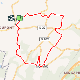

Length
9.2 km

Max alt
917 m

Uphill gradient
201 m
Km-Effort
11.8 km

Min alt
767 m

Downhill gradient
202 m
Boucle
Yes
Creation date :
2014-12-10 00:00:00.0
Updated on :
2014-12-10 00:00:00.0
3h40
Difficulty : Easy

FREE GPS app for hiking
 SityTrail
IGN / Geographical institutes
SityTrail Plus
The world is yours!
About
Trail Walking of 9.2 km to be discovered at Auvergne-Rhône-Alpes, Upper Savoy, Fillière. This trail is proposed by COMAN.
Description
Randonnée autour de Le Chaumet
Positioning
Country:
France
Region :
Auvergne-Rhône-Alpes
Department/Province :
Upper Savoy
Municipality :
Fillière
Location:
Évires
Start:(Dec)
Start:(UTM)
284131 ; 5103762 (32T) N.
Comments