


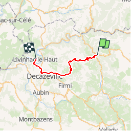
10 è etapes ConquesLlivinhac le haut

RoMo
User

Length
25 km

Max alt
581 m

Uphill gradient
920 m
Km-Effort
37 km

Min alt
177 m

Downhill gradient
979 m
Boucle
No
Creation date :
2019-10-21 09:04:45.047
Updated on :
2019-10-21 09:06:51.805
--
Difficulty : Difficult

FREE GPS app for hiking
 SityTrail
IGN / Geographical institutes
SityTrail Plus
The world is yours!
About
Trail On foot of 25 km to be discovered at Occitania, Aveyron, Conques-en-Rouergue. This trail is proposed by RoMo.
Positioning
Country:
France
Region :
Occitania
Department/Province :
Aveyron
Municipality :
Conques-en-Rouergue
Location:
Unknown
Start:(Dec)
Start:(UTM)
452099 ; 4938562 (31T) N.
Comments