bouzeron

LUCIE2016
User

Length
12.2 km

Max alt
365 m

Uphill gradient
448 m
Km-Effort
18.1 km

Min alt
231 m

Downhill gradient
447 m
Boucle
Yes
Creation date :
2019-10-21 11:36:37.749
Updated on :
2019-10-22 08:39:51.233
2h56
Difficulty : Easy

FREE GPS app for hiking
 SityTrail
IGN / Geographical institutes
SityTrail Plus
The world is yours!
About
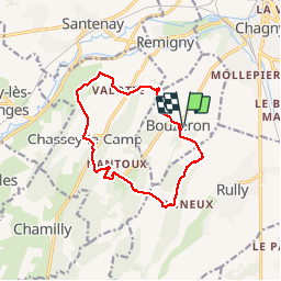
Trail Walking of 12.2 km to be discovered at Bourgogne-Franche-Comté, Saône-et-Loire, Bouzeron. This trail is proposed by LUCIE2016.
Positioning
Country:
France
Region :
Bourgogne-Franche-Comté
Department/Province :
Saône-et-Loire
Municipality :
Bouzeron
Location:
Unknown
Start:(Dec)
Start:(UTM)
631660 ; 5194303 (31T) N.
Comments