


Beauvène

raygautier
User
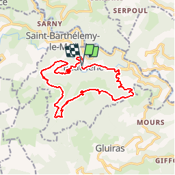

Length
16 km

Max alt
794 m

Uphill gradient
730 m
Km-Effort
26 km

Min alt
352 m

Downhill gradient
736 m
Boucle
Yes
Creation date :
2019-10-22 10:46:49.548
Updated on :
2019-10-22 10:48:30.206
--
Difficulty : Medium

FREE GPS app for hiking
 SityTrail
IGN / Geographical institutes
SityTrail Plus
The world is yours!
About
Trail On foot of 16 km to be discovered at Auvergne-Rhône-Alpes, Ardèche, Beauvène. This trail is proposed by raygautier.
Description
moyenne
Positioning
Country:
France
Region :
Auvergne-Rhône-Alpes
Department/Province :
Ardèche
Municipality :
Beauvène
Location:
Unknown
Start:(Dec)
Start:(UTM)
619244 ; 4970322 (31T) N.
Comments