


chabrinel

raygautier
User
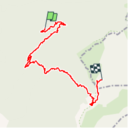

Length
8.6 km

Max alt
1734 m

Uphill gradient
861 m
Km-Effort
18 km

Min alt
1004 m

Downhill gradient
211 m
Boucle
No
Creation date :
2019-10-17 07:16:38.599
Updated on :
2019-10-22 10:50:46.308
3h35
Difficulty : Very easy

FREE GPS app for hiking
 SityTrail
IGN / Geographical institutes
SityTrail Plus
The world is yours!
About
Trail Walking of 8.6 km to be discovered at Auvergne-Rhône-Alpes, Drôme, Romeyer. This trail is proposed by raygautier.
Positioning
Country:
France
Region :
Auvergne-Rhône-Alpes
Department/Province :
Drôme
Municipality :
Romeyer
Location:
Unknown
Start:(Dec)
Start:(UTM)
693479 ; 4964408 (31T) N.
Comments