


pech de Bugarach

jeanic63
User
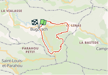

Length
12.7 km

Max alt
1210 m

Uphill gradient
809 m
Km-Effort
23 km

Min alt
461 m

Downhill gradient
808 m
Boucle
Yes
Creation date :
2019-10-23 16:46:35.405
Updated on :
2020-10-10 08:23:33.643
--
Difficulty : Very difficult

FREE GPS app for hiking
 SityTrail
IGN / Geographical institutes
SityTrail Plus
The world is yours!
About
Trail On foot of 12.7 km to be discovered at Occitania, Aude, Bugarach. This trail is proposed by jeanic63.
Description
départ village de bugarach
Positioning
Country:
France
Region :
Occitania
Department/Province :
Aude
Municipality :
Bugarach
Location:
Unknown
Start:(Dec)
Start:(UTM)
446999 ; 4747195 (31T) N.
Comments