


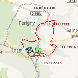
Le Val Mérienne

gr1346
User

Length
6 km

Max alt
221 m

Uphill gradient
144 m
Km-Effort
7.9 km

Min alt
127 m

Downhill gradient
141 m
Boucle
Yes
Creation date :
2014-12-10 00:00:00.0
Updated on :
2014-12-10 00:00:00.0
1h43
Difficulty : Medium

FREE GPS app for hiking
 SityTrail
IGN / Geographical institutes
SityTrail Plus
The world is yours!
About
Trail Walking of 6 km to be discovered at Normandy, Calvados, Périgny. This trail is proposed by gr1346.
Positioning
Country:
France
Region :
Normandy
Department/Province :
Calvados
Municipality :
Périgny
Location:
Unknown
Start:(Dec)
Start:(UTM)
675773 ; 5420206 (30U) N.
Comments