


V 2019 27 & 29/10 Saint Sernin du Plain

clabidault
User
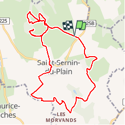

Length
11.3 km

Max alt
542 m

Uphill gradient
330 m
Km-Effort
15.7 km

Min alt
304 m

Downhill gradient
330 m
Boucle
Yes
Creation date :
2019-10-24 11:28:50.444
Updated on :
2019-11-06 20:54:13.535
3h13
Difficulty : Medium

FREE GPS app for hiking
 SityTrail
IGN / Geographical institutes
SityTrail Plus
The world is yours!
About
Trail Walking of 11.3 km to be discovered at Bourgogne-Franche-Comté, Saône-et-Loire, Saint-Sernin-du-Plain. This trail is proposed by clabidault.
Positioning
Country:
France
Region :
Bourgogne-Franche-Comté
Department/Province :
Saône-et-Loire
Municipality :
Saint-Sernin-du-Plain
Location:
Unknown
Start:(Dec)
Start:(UTM)
623699 ; 5195252 (31T) N.
Comments