


barbenoir

COMAN
User
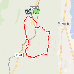

Length
6.2 km

Max alt
985 m

Uphill gradient
258 m
Km-Effort
9.7 km

Min alt
788 m

Downhill gradient
268 m
Boucle
Yes
Creation date :
2019-10-25 12:08:46.877
Updated on :
2019-10-25 16:17:00.003
3h01
Difficulty : Very easy

FREE GPS app for hiking
 SityTrail
IGN / Geographical institutes
SityTrail Plus
The world is yours!
About
Trail Walking of 6.2 km to be discovered at Auvergne-Rhône-Alpes, Upper Savoy, Annecy. This trail is proposed by COMAN.
Photos


Positioning
Country:
France
Region :
Auvergne-Rhône-Alpes
Department/Province :
Upper Savoy
Municipality :
Annecy
Location:
Annecy
Start:(Dec)
Start:(UTM)
276550 ; 5083243 (32T) N.
Comments