Trail Walking Prades - 20191026 sortie Polio - Photo
 ThonyM
ThonyM

User

© OpenStreetMap contributors
Length
Length
4.6 km
Max alt
Max alt
516 m
Uphill gradient
Uphill gradient
180 m
Km-Effort
Km-Effort  
7 km
Min alt
Min alt
339 m
Downhill gradient
Downhill gradient
184 m
Boucle
Boucle
Yes
Creation date :
2019-10-26 08:19:12.0
Updated on :
2019-10-26 10:05:30.773

(0 Reviews)

Walking
Walking
1h45
Difficulty : Unknown

Scan this QR Code to open this trail in the SityTrail application

FREE GPS app for hiking

Logo SityTrail SityTrail

IGN / Geographical institutes

Download SityTrail from the App Store Download SityTrail from Google Play

Logo SityTrail SityTrail World

The world is yours!

Download SityTrail from the App Store Download SityTrail from Google Play Download SityTrail on Huawei AppGallery

About

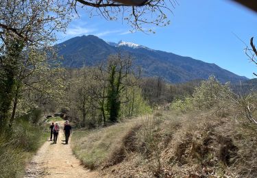
Trail Walking of 4.6 km to be discovered at Occitania, Pyrénées-Orientales, Prades. This trail is proposed by ThonyM.

Description

Marche magnifique en faveur de l’éradication de la polio dans le monde. Bravo les marcheurs

Elevation profile

Positioning

Country:
France
Region :
Occitania
Department/Province :
Pyrénées-Orientales
Municipality :
Prades
Location:
Unknown
Start:(UTM)
452324 ; 4719483 (31T) N.

Trails nearby

Trail Walking Ria-Sirach - Sirach-Taurinya-Saint Michel de Cuxa - Photo
Walking
ThonyM

Walking

Easy
(2)
Ria-Sirach, Occitania, Pyrénées-Orientales, France
13.5 km | 17.2 km-effort
2h 31min
Yes
Trail Motor Codalet - Prades - Villefranche de Conflent - Evol  - Photo
Motor
crijack

Motor

Easy
(1)
Codalet, Occitania, Pyrénées-Orientales, France
36 km | 48 km-effort
3h 47min
No
Trail Mountain bike Ria-Sirach - cami del pi - Photo
Mountain bike
fine66

Mountain bike

Very easy
(1)
Ria-Sirach, Occitania, Pyrénées-Orientales, France
11.2 km | 18.4 km-effort
1h 52min
Yes
Trail Walking Clara-Villerach - clara villerach parking du Liech Lcara - Photo
Walking
bouardlaurent

Walking

Medium
Clara-Villerach, Occitania, Pyrénées-Orientales, France
9.6 km | 14.2 km-effort
2h 54min
Yes
Trail Walking Catllar - cap Béarn depuis port vendres - Photo
Walking
66Gribouille83

Walking

Very difficult
Catllar, Occitania, Pyrénées-Orientales, France
111 km | 126 km-effort
49h 38min
No
Trail Walking Los Masos - Los Masos Lionat - Photo
Walking
ombrabella

Walking

Very easy
Los Masos, Occitania, Pyrénées-Orientales, France
11.2 km | 15.5 km-effort
3h 11min
Yes
Trail Walking Fuilla - Ville franche / fort Liberia /Chapelle St André de Bell lloc / St esteve de calmeilles - Photo
Walking
robertperello

Walking

Medium
Fuilla, Occitania, Pyrénées-Orientales, France
11.5 km | 21 km-effort
3h 39min
Yes
Trail Walking Codalet - taurinya tour de corts - Photo
Walking
66Gribouille83

Walking

Very difficult
Codalet, Occitania, Pyrénées-Orientales, France
12.7 km | 19.2 km-effort
6h 16min
Yes
Trail Walking Ria-Sirach - 20221117 une boucle depuis Sirach - Photo
Walking
ThonyM

Walking

Difficult
Ria-Sirach, Occitania, Pyrénées-Orientales, France
18.5 km | 33 km-effort
5h 24min
Yes


Close
My subscriptions