


reals

Daron34
User
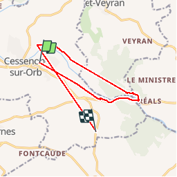

Length
13.8 km

Max alt
159 m

Uphill gradient
289 m
Km-Effort
17.4 km

Min alt
27 m

Downhill gradient
223 m
Boucle
No
Creation date :
2019-10-26 07:33:50.455
Updated on :
2019-10-26 10:41:10.141
2h11
Difficulty : Easy

FREE GPS app for hiking
 SityTrail
IGN / Geographical institutes
SityTrail Plus
The world is yours!
About
Trail Walking of 13.8 km to be discovered at Occitania, Hérault, Cessenon-sur-Orb. This trail is proposed by Daron34.
Positioning
Country:
France
Region :
Occitania
Department/Province :
Hérault
Municipality :
Cessenon-sur-Orb
Location:
Unknown
Start:(Dec)
Start:(UTM)
504345 ; 4810859 (31T) N.
Comments