


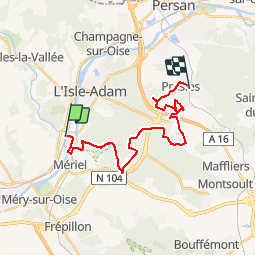
De Valmondois à Presles par la Forêt de l'Isle-Adam

NUITEVEN
User

Length
20 km

Max alt
198 m

Uphill gradient
320 m
Km-Effort
25 km

Min alt
24 m

Downhill gradient
294 m
Boucle
No
Creation date :
2019-10-26 13:17:39.846
Updated on :
2019-11-06 11:49:29.51
5h21
Difficulty : Very difficult

FREE GPS app for hiking
 SityTrail
IGN / Geographical institutes
SityTrail Plus
The world is yours!
About
Trail Walking of 20 km to be discovered at Ile-de-France, Val-d'Oise, Butry-sur-Oise. This trail is proposed by NUITEVEN.
Positioning
Country:
France
Region :
Ile-de-France
Department/Province :
Val-d'Oise
Municipality :
Butry-sur-Oise
Location:
Unknown
Start:(Dec)
Start:(UTM)
441764 ; 5437969 (31U) N.
Comments