


2019 10 T1

michel1025
User
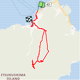

Length
11.6 km

Max alt
522 m

Uphill gradient
745 m
Km-Effort
22 km

Min alt
0 m

Downhill gradient
741 m
Boucle
No
Creation date :
2019-10-15 00:29:52.0
Updated on :
2019-10-26 14:31:51.784
3h46
Difficulty : Unknown

FREE GPS app for hiking
 SityTrail
IGN / Geographical institutes
SityTrail Plus
The world is yours!
About
Trail Walking of 11.6 km to be discovered at Hiroshima Prefecture, Unknown, Unknown. This trail is proposed by michel1025.
Positioning
Country:
Japan
Region :
Hiroshima Prefecture
Department/Province :
Unknown
Municipality :
Unknown
Location:
Itsukushima
Start:(Dec)
Start:(UTM)
253569 ; 3798898 (53S) N.
Comments