


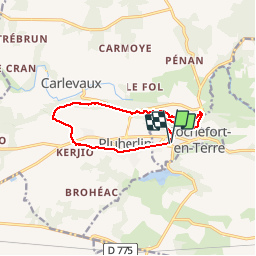
Pluherlin, Les Grées

ollivier.albert
User

Length
11 km

Max alt
87 m

Uphill gradient
139 m
Km-Effort
12.9 km

Min alt
26 m

Downhill gradient
141 m
Boucle
Yes
Creation date :
2019-10-26 13:17:30.391
Updated on :
2019-10-26 17:35:39.057
3h21
Difficulty : Very easy

FREE GPS app for hiking
 SityTrail
IGN / Geographical institutes
SityTrail Plus
The world is yours!
About
Trail Walking of 11 km to be discovered at Brittany, Morbihan, Rochefort-en-Terre. This trail is proposed by ollivier.albert.
Photos


Positioning
Country:
France
Region :
Brittany
Department/Province :
Morbihan
Municipality :
Rochefort-en-Terre
Location:
Unknown
Start:(Dec)
Start:(UTM)
548991 ; 5282998 (30T) N.
Comments