


Canal de Jouy aux Arches vers Metz

edmondnagel
User

Length
6.4 km

Max alt
174 m

Uphill gradient
32 m
Km-Effort
6.8 km

Min alt
162 m

Downhill gradient
32 m
Boucle
Yes
Creation date :
2014-12-10 00:00:00.0
Updated on :
2014-12-10 00:00:00.0
1h32
Difficulty : Very easy

FREE GPS app for hiking
 SityTrail
IGN / Geographical institutes
SityTrail Plus
The world is yours!
About
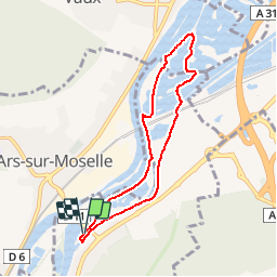
Trail Walking of 6.4 km to be discovered at Grand Est, Moselle, Jouy-aux-Arches. This trail is proposed by edmondnagel.
Description
Départ parking côté gauche du pont de la Moselle (D11 vers Ars sur Moselle). On longe le canal de Jouy direction Metz, en empruntant le véloroute Charles le Téméraire, puis retour sur l'autre rive.
Positioning
Country:
France
Region :
Grand Est
Department/Province :
Moselle
Municipality :
Jouy-aux-Arches
Location:
Unknown
Start:(Dec)
Start:(UTM)
286833 ; 5439294 (32U) N.
Comments