


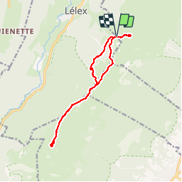
SityTrail - Lélex - Crêt de la Neige

UDGI54
User


4h22
Difficulty : Very difficult

FREE GPS app for hiking
 SityTrail
IGN / Geographical institutes
SityTrail Plus
The world is yours!
About
Trail Walking of 13.6 km to be discovered at Auvergne-Rhône-Alpes, Ain, Crozet. This trail is proposed by UDGI54.
Description
Dernière sortie saison raquettes, groupe de 23, ensoleillement moyen, belle ballade, casse croûte au Crêt. Départ Lélex, télécabine de la Catheline, montée au Grand Crêt pour le Crêt de la Neige, retour par Brillonne d'en Haut au télécabine. Petite boucle au Col du Crozet (belvédère et table d’orientation).
Positioning
Comments