


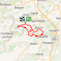
Fraiture Sprimont

j.fleron@skynet.be
User

Length
21 km

Max alt
289 m

Uphill gradient
529 m
Km-Effort
28 km

Min alt
109 m

Downhill gradient
530 m
Boucle
Yes
Creation date :
2019-10-27 11:45:05.702
Updated on :
2019-10-27 14:45:41.111
2h59
Difficulty : Very easy

FREE GPS app for hiking
 SityTrail
IGN / Geographical institutes
SityTrail Plus
The world is yours!
About
Trail Running of 21 km to be discovered at Wallonia, Liège, Sprimont. This trail is proposed by j.fleron@skynet.be.
Positioning
Country:
Belgium
Region :
Wallonia
Department/Province :
Liège
Municipality :
Sprimont
Location:
Sprimont
Start:(Dec)
Start:(UTM)
686348 ; 5597020 (31U) N.
Comments