


Esterel

murazzano
User
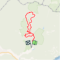

Length
14.6 km

Max alt
252 m

Uphill gradient
495 m
Km-Effort
21 km

Min alt
43 m

Downhill gradient
495 m
Boucle
Yes
Creation date :
2019-10-27 07:03:24.767
Updated on :
2019-10-27 17:49:36.03
7h08
Difficulty : Easy

FREE GPS app for hiking
 SityTrail
IGN / Geographical institutes
SityTrail Plus
The world is yours!
About
Trail Walking of 14.6 km to be discovered at Provence-Alpes-Côte d'Azur, Var, Saint-Raphaël. This trail is proposed by murazzano.
Positioning
Country:
France
Region :
Provence-Alpes-Côte d'Azur
Department/Province :
Var
Municipality :
Saint-Raphaël
Location:
Unknown
Start:(Dec)
Start:(UTM)
327568 ; 4813709 (32T) N.
Comments