


andelnans 2

alexbnmr
User
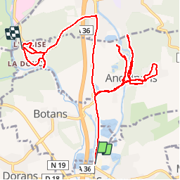

Length
14.7 km

Max alt
385 m

Uphill gradient
175 m
Km-Effort
16.9 km

Min alt
340 m

Downhill gradient
146 m
Boucle
No
Creation date :
2014-12-10 00:00:00.0
Updated on :
2014-12-10 00:00:00.0
2h08
Difficulty : Unknown

FREE GPS app for hiking
 SityTrail
IGN / Geographical institutes
SityTrail Plus
The world is yours!
About
Trail Other activity of 14.7 km to be discovered at Bourgogne-Franche-Comté, Territoire-de-Belfort, Sevenans. This trail is proposed by alexbnmr.
Points of interest


Positioning
Country:
France
Region :
Bourgogne-Franche-Comté
Department/Province :
Territoire-de-Belfort
Municipality :
Sevenans
Location:
Unknown
Start:(Dec)
Start:(UTM)
339059 ; 5272814 (32T) N.
Comments