Trail Walking Miribel - A_MIRIBEL 01700 La Droite - Brotteau de Crêt - Photo

A_MIRIBEL 01700 La Droite - Brotteau de Crêt

 ANDREJAC
ANDREJAC

User

© OpenStreetMap contributors
Length
Length
7 km
Max alt
Max alt
182 m
Uphill gradient
Uphill gradient
40 m
Km-Effort
Km-Effort  
7.5 km
Min alt
Min alt
170 m
Downhill gradient
Downhill gradient
40 m
Boucle
Boucle
Yes
Creation date :
2014-12-10 00:00:00.0
Updated on :
2014-12-10 00:00:00.0

(2 Reviews)

Walking
Walking
3h00
Difficulty : Very easy

Scan this QR Code to open this trail in the SityTrail application

FREE GPS app for hiking

Logo SityTrail SityTrail

IGN / Geographical institutes

Download SityTrail from the App Store Download SityTrail from Google Play

Logo SityTrail SityTrail World

The world is yours!

Download SityTrail from the App Store Download SityTrail from Google Play Download SityTrail on Huawei AppGallery

About

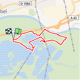
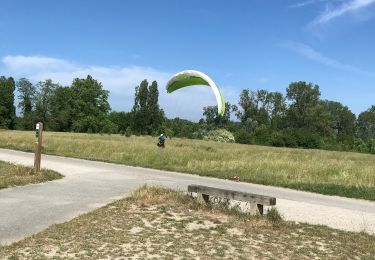
Trail Walking of 7 km to be discovered at Auvergne-Rhône-Alpes, Ain, Miribel. This trail is proposed by ANDREJAC.

Description

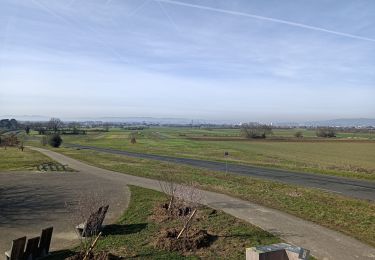
Départ et retour du parking La Droite.
En forêt jusqu'au canal de Jonage. Le long du canal jusqu'au Brotteau de Crêt. Retour par Rayament, belvédère du Drapeau. Côte 174, puis 176, et parking.

Elevation profile

Positioning

Country:
France
Region :
Auvergne-Rhône-Alpes
Department/Province :
Ain
Municipality :
Miribel
Location:
Unknown
Start:(UTM)
652357 ; 5075152 (31T) N.

Comments

Please log in to post a review or rate the element


Trails nearby

Trail Mountain bike Vaulx-en-Velin - Parc de Miribel Jonage -Les chemins de halages - Vaulx en Velin - Photo
Mountain bike
tracegps

Mountain bike

Medium
(1)
Vaulx-en-Velin, Auvergne-Rhône-Alpes, Métropole de Lyon, France
37 km | 41 km-effort
2h 30min
Yes
Trail Walking Miribel - 01_Madone_Miribel_12km190m - Photo
Walking
SyMA

Walking

Medium
Miribel, Auvergne-Rhône-Alpes, Ain, France
12.1 km | 14.7 km-effort
3h 35min
Yes
Trail Walking Miribel - 01-miribel-madone-13km250m - Photo
Walking
SyMA

Walking

Easy
Miribel, Auvergne-Rhône-Alpes, Ain, France
13 km | 16.3 km-effort
2h 50min
Yes
Trail Walking Décines-Charpieu - 69-Meribel-grand-tour-du-lac-12km - Photo
Walking
SyMA

Walking

Medium
Décines-Charpieu, Auvergne-Rhône-Alpes, Métropole de Lyon, France
12.2 km | 13.3 km-effort
2h 36min
Yes
Trail Walking Miribel - Miribel circuit de la Madone 02 - Photo
Walking
vaud

Walking

Medium
(1)
Miribel, Auvergne-Rhône-Alpes, Ain, France
12.7 km | 16 km-effort
4h 22min
Yes
Trail Mountain bike Décines-Charpieu - Canal de Jonage et canal de Méribel - Photo
Mountain bike
eoriol

Mountain bike

Easy
(1)
Décines-Charpieu, Auvergne-Rhône-Alpes, Métropole de Lyon, France
35 km | 39 km-effort
2h 16min
Yes
Trail Walking Décines-Charpieu - Espace Biezin DECINES - Photo
Walking
chuck

Walking

Very easy
Décines-Charpieu, Auvergne-Rhône-Alpes, Métropole de Lyon, France
10.9 km | 12.1 km-effort
2h 51min
Yes
Trail Mountain bike Décines-Charpieu - Le tour du parc Miribel - Photo
Mountain bike
ericgerb

Mountain bike

Difficult
Décines-Charpieu, Auvergne-Rhône-Alpes, Métropole de Lyon, France
31 km | 34 km-effort
1h 35min
Yes
Trail Walking Beynost - cibleBeynost - Photo
Walking
adelore

Walking

Very easy
Beynost, Auvergne-Rhône-Alpes, Ain, France
1.2 km | 1.4 km-effort
37min
No


Close
My subscriptions