


la butte gendarmes

martelli
User
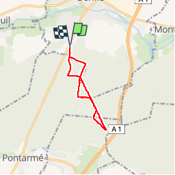

Length
10.1 km

Max alt
103 m

Uphill gradient
74 m
Km-Effort
11.1 km

Min alt
58 m

Downhill gradient
72 m
Boucle
Yes
Creation date :
2014-12-10 00:00:00.0
Updated on :
2014-12-10 00:00:00.0
2h24
Difficulty : Unknown

FREE GPS app for hiking
 SityTrail
IGN / Geographical institutes
SityTrail Plus
The world is yours!
About
Trail Other activity of 10.1 km to be discovered at Hauts-de-France, Oise, Senlis. This trail is proposed by martelli.
Photos

Positioning
Country:
France
Region :
Hauts-de-France
Department/Province :
Oise
Municipality :
Senlis
Location:
Unknown
Start:(Dec)
Start:(UTM)
468993 ; 5448729 (31U) N.
Comments