


Hastiere-13-10-13

ameurant
User
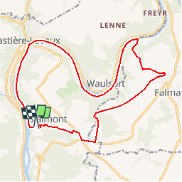

Length
17.5 km

Max alt
267 m

Uphill gradient
380 m
Km-Effort
22 km

Min alt
92 m

Downhill gradient
329 m
Boucle
No
Creation date :
2014-12-10 00:00:00.0
Updated on :
2014-12-10 00:00:00.0
3h00
Difficulty : Very easy

FREE GPS app for hiking
 SityTrail
IGN / Geographical institutes
SityTrail Plus
The world is yours!
About
Trail Walking of 17.5 km to be discovered at Wallonia, Namur, Hastière. This trail is proposed by ameurant.
Positioning
Country:
Belgium
Region :
Wallonia
Department/Province :
Namur
Municipality :
Hastière
Location:
Blaimont
Start:(Dec)
Start:(UTM)
630511 ; 5561282 (31U) N.
Comments