


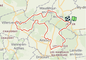
Enfer, Aincourt, Villers, Maudétour et Arthies

philberard95
User

Length
23 km

Max alt
216 m

Uphill gradient
451 m
Km-Effort
29 km

Min alt
118 m

Downhill gradient
457 m
Boucle
Yes
Creation date :
2019-10-24 07:41:39.179
Updated on :
2023-01-11 11:12:11.744
5h44
Difficulty : Medium

FREE GPS app for hiking
 SityTrail
IGN / Geographical institutes
SityTrail Plus
The world is yours!
About
Trail Walking of 23 km to be discovered at Ile-de-France, Val-d'Oise, Wy-dit-Joli-Village. This trail is proposed by philberard95.
Positioning
Country:
France
Region :
Ile-de-France
Department/Province :
Val-d'Oise
Municipality :
Wy-dit-Joli-Village
Location:
Unknown
Start:(Dec)
Start:(UTM)
412982 ; 5437789 (31U) N.
Comments