


Boult 31 oct 2019

TRIMAILLE
User
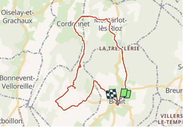

Length
18.2 km

Max alt
353 m

Uphill gradient
340 m
Km-Effort
23 km

Min alt
232 m

Downhill gradient
340 m
Boucle
Yes
Creation date :
2019-10-31 07:32:27.984
Updated on :
2019-12-11 13:06:02.074
6h10
Difficulty : Difficult

FREE GPS app for hiking
 SityTrail
IGN / Geographical institutes
SityTrail Plus
The world is yours!
About
Trail Walking of 18.2 km to be discovered at Bourgogne-Franche-Comté, Haute-Saône, Boult. This trail is proposed by TRIMAILLE.
Positioning
Country:
France
Region :
Bourgogne-Franche-Comté
Department/Province :
Haute-Saône
Municipality :
Boult
Location:
Unknown
Start:(Dec)
Start:(UTM)
273684 ; 5251750 (32T) N.
Comments