olivier26

olivier26
User
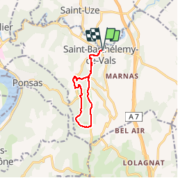

Length
9.5 km

Max alt
289 m

Uphill gradient
264 m
Km-Effort
13.1 km

Min alt
171 m

Downhill gradient
265 m
Boucle
Yes
Creation date :
2014-12-10 00:00:00.0
Updated on :
2014-12-10 00:00:00.0
2h27
Difficulty : Unknown

FREE GPS app for hiking
 SityTrail
IGN / Geographical institutes
SityTrail Plus
The world is yours!
About
Trail Other activity of 9.5 km to be discovered at Auvergne-Rhône-Alpes, Drôme, Saint-Barthélemy-de-Vals. This trail is proposed by olivier26.
Positioning
Country:
France
Region :
Auvergne-Rhône-Alpes
Department/Province :
Drôme
Municipality :
Saint-Barthélemy-de-Vals
Location:
Unknown
Start:(Dec)
Start:(UTM)
647196 ; 5003565 (31T) N.
Comments