


Rogeville

PhilippeC54
User
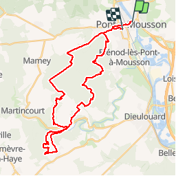

Length
37 km

Max alt
347 m

Uphill gradient
669 m
Km-Effort
46 km

Min alt
178 m

Downhill gradient
671 m
Boucle
No
Creation date :
2019-11-01 07:26:52.851
Updated on :
2019-11-27 07:44:28.642
3h21
Difficulty : Very easy

FREE GPS app for hiking
 SityTrail
IGN / Geographical institutes
SityTrail Plus
The world is yours!
About
Trail Mountain bike of 37 km to be discovered at Grand Est, Meurthe-et-Moselle, Pont-à-Mousson. This trail is proposed by PhilippeC54.
Description
monotraces Rogeville & Puvenelle
Positioning
Country:
France
Region :
Grand Est
Department/Province :
Meurthe-et-Moselle
Municipality :
Pont-à-Mousson
Location:
Unknown
Start:(Dec)
Start:(UTM)
284267 ; 5420957 (32U) N.
Comments