


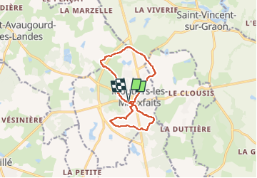
R8-Moutiers les Mauxfaits

gegedo
User

Length
11.8 km

Max alt
68 m

Uphill gradient
97 m
Km-Effort
13.1 km

Min alt
22 m

Downhill gradient
96 m
Boucle
Yes
Creation date :
2019-10-22 07:02:01.672
Updated on :
2022-09-05 14:43:18.094
2h15
Difficulty : Very easy

FREE GPS app for hiking
 SityTrail
IGN / Geographical institutes
SityTrail Plus
The world is yours!
About
Trail Walking of 11.8 km to be discovered at Pays de la Loire, Vendée, Moutiers-les-Mauxfaits. This trail is proposed by gegedo.
Description
RAS
Positioning
Country:
France
Region :
Pays de la Loire
Department/Province :
Vendée
Municipality :
Moutiers-les-Mauxfaits
Location:
Unknown
Start:(Dec)
Start:(UTM)
620492 ; 5149815 (30T) N.
Comments
à fzire par temps sec !