Trail Walking Couflens - 2019-11-02_22h04m24_-4.o - Photo

2019-11-02_22h04m24_-4.o

 dawed311
dawed311

User

© OpenStreetMap contributors
Length
Length
18.8 km
Max alt
Max alt
2094 m
Uphill gradient
Uphill gradient
1179 m
Km-Effort
Km-Effort  
35 km
Min alt
Min alt
973 m
Downhill gradient
Downhill gradient
1177 m
Boucle
Boucle
Yes
Creation date :
2019-11-02 21:04:27.47
Updated on :
2020-02-17 20:21:02.607

(0 Reviews)

Walking
Walking
6h57
Difficulty : Medium

Scan this QR Code to open this trail in the SityTrail application

FREE GPS app for hiking

Logo SityTrail SityTrail

IGN / Geographical institutes

Download SityTrail from the App Store Download SityTrail from Google Play

Logo SityTrail SityTrail World

The world is yours!

Download SityTrail from the App Store Download SityTrail from Google Play Download SityTrail on Huawei AppGallery

About

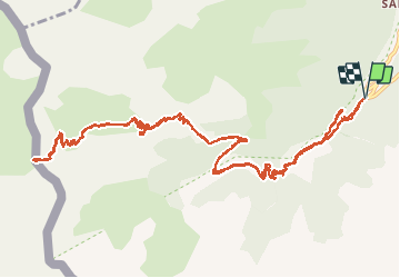
Trail Walking of 18.8 km to be discovered at Occitania, Ariège, Couflens. This trail is proposed by dawed311.

Description

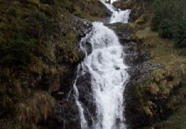
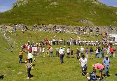
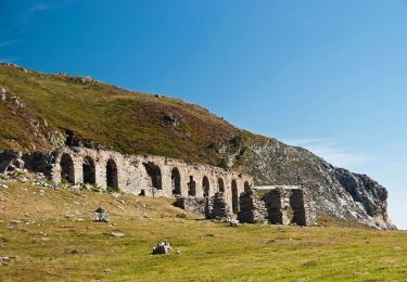
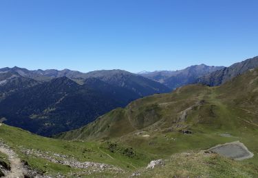
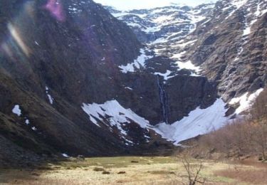
Montée classique au Port de Salau et à sa "cathédrale". Un petite cascade sur le début du parcours à visiter, elle n'est pas visible du chemin mais se trouve à 2 min seulement. Montée régulière jusqu'au sommet. Attention à ne pas suivre les bâtiments au milieu de la montée, le chemin part sur la droite, pas de possibilité de rejoindre . Le brouillard au sommet nous a empêché de monter au pic de Portabère pour avoir une vue plongeante sur le bâtiment et le col. Randonnée malgré tout bien agréable sur les traces des travailleurs du bois.

Elevation profile

Positioning

Country:
France
Region :
Occitania
Department/Province :
Ariège
Municipality :
Couflens
Location:
Unknown
Start:(UTM)
351229 ; 4734299 (31T) N.

Trails nearby

Trail Walking Couflens - Cascade de Léziou - Photo
Walking
tracegps

Walking

Medium
(1)
Couflens, Occitania, Ariège, France
4.1 km | 6.3 km-effort
1h 45min
Yes
Trail Walking Couflens - Port de Salau - Photo
Walking
tracegps

Walking

Difficult
Couflens, Occitania, Ariège, France
9.1 km | 20 km-effort
3h 30min
No
Trail Mountain bike Couflens - Le Port d' Aula - Photo
Mountain bike
tracegps

Mountain bike

Very difficult
(1)
Couflens, Occitania, Ariège, France
18 km | 37 km-effort
5h 0min
No
Trail Walking Couflens - Cirque d''Anglade - Ariège - Photo
Walking
sebcho

Walking

Very easy
Couflens, Occitania, Ariège, France
4.7 km | 11.3 km-effort
Unknown
No
Trail Walking Couflens - Cirque d''Anglade - Ariège - Photo
Walking
sebcho

Walking

Very easy
Couflens, Occitania, Ariège, France
4.7 km | 11.3 km-effort
Unknown
No
Trail On foot Alt Àneu - route du Port de Salau - Photo
On foot
PRO

On foot

Easy
Alt Àneu, Catalonia, Lleida, Spain
8.4 km | 12.2 km-effort
2h 45min
No
Trail Walking Seix - Port d'Aula - Photo
Walking
GuyVachet

Walking

Medium
(1)
Seix, Occitania, Ariège, France
14.4 km | 24 km-effort
6h 42min
Yes
Trail Walking Couflens - La Lanette - Photo
Walking
tracegps

Walking

Medium
Couflens, Occitania, Ariège, France
8.4 km | 15.3 km-effort
3h 0min
Yes
Trail Walking Couflens - Le cirque d'Anglade - Photo
Walking
tracegps

Walking

Difficult
Couflens, Occitania, Ariège, France
8.3 km | 17.6 km-effort
3h 30min
Yes


Close
My subscriptions