


Les Avins Bob Octobre 2019

r.genette
User
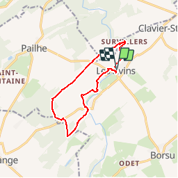

Length
10.5 km

Max alt
299 m

Uphill gradient
190 m
Km-Effort
13 km

Min alt
206 m

Downhill gradient
189 m
Boucle
Yes
Creation date :
2019-11-03 13:55:05.981
Updated on :
2019-11-03 14:04:28.062
--
Difficulty : Easy

FREE GPS app for hiking
 SityTrail
IGN / Geographical institutes
SityTrail Plus
The world is yours!
About
Trail On foot of 10.5 km to be discovered at Wallonia, Liège, Clavier. This trail is proposed by r.genette.
Description
rando à découvrir.. beaux sentiers.. des bois.. un peu de dénivelé..et une belle rivière.. Le Laid Homme... le Hoyoux...
Positioning
Country:
Belgium
Region :
Wallonia
Department/Province :
Liège
Municipality :
Clavier
Location:
Les Avins
Start:(Dec)
Start:(UTM)
663391 ; 5587347 (31U) N.
Comments