


NewTrack

coglais
User
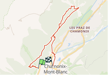

Length
8.4 km

Max alt
1397 m

Uphill gradient
424 m
Km-Effort
14.3 km

Min alt
1037 m

Downhill gradient
491 m
Boucle
No
Creation date :
2019-11-03 16:16:58.944
Updated on :
2022-05-28 13:35:44.419
3h20
Difficulty : Difficult

FREE GPS app for hiking
 SityTrail
IGN / Geographical institutes
SityTrail Plus
The world is yours!
About
Trail Nordic walking of 8.4 km to be discovered at Auvergne-Rhône-Alpes, Upper Savoy, Chamonix-Mont-Blanc. This trail is proposed by coglais.
Positioning
Country:
France
Region :
Auvergne-Rhône-Alpes
Department/Province :
Upper Savoy
Municipality :
Chamonix-Mont-Blanc
Location:
Unknown
Start:(Dec)
Start:(UTM)
334290 ; 5087905 (32T) N.
Comments