


SityTrail - JUJOLS

UDGI54
User
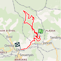

Length
19.3 km

Max alt
1781 m

Uphill gradient
888 m
Km-Effort
32 km

Min alt
623 m

Downhill gradient
1227 m
Boucle
No
Creation date :
2019-11-04 11:54:48.311
Updated on :
2019-11-04 12:00:41.183

FREE GPS app for hiking
 SityTrail
IGN / Geographical institutes
SityTrail Plus
The world is yours!
About
Trail of 19.3 km to be discovered at Occitania, Pyrénées-Orientales, Jujols. This trail is proposed by UDGI54.
Positioning
Country:
France
Region :
Occitania
Department/Province :
Pyrénées-Orientales
Municipality :
Jujols
Location:
Unknown
Start:(Dec)
Start:(UTM)
442122 ; 4713225 (31T) N.
Comments