


1111122

Dupuybadonniere
User
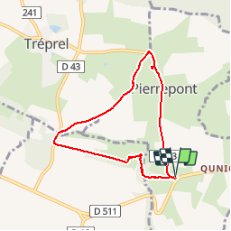

Length
6.2 km

Max alt
245 m

Uphill gradient
100 m
Km-Effort
7.6 km

Min alt
181 m

Downhill gradient
98 m
Boucle
Yes
Creation date :
2019-11-09 08:33:04.839
Updated on :
2019-11-09 10:24:05.355
1h50
Difficulty : Very easy

FREE GPS app for hiking
 SityTrail
IGN / Geographical institutes
SityTrail Plus
The world is yours!
About
Trail Walking of 6.2 km to be discovered at Normandy, Calvados, Pierrepont. This trail is proposed by Dupuybadonniere.
Positioning
Country:
France
Region :
Normandy
Department/Province :
Calvados
Municipality :
Pierrepont
Location:
Unknown
Start:(Dec)
Start:(UTM)
696316 ; 5417677 (30U) N.
Comments