


Boucles Ardennaises Marathon Trail 2025

laurentgoffinet
User
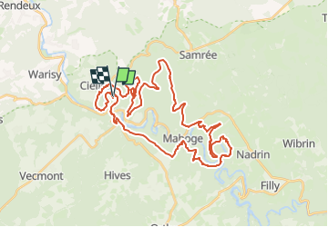

Length
41 km

Max alt
565 m

Uphill gradient
1530 m
Km-Effort
62 km

Min alt
210 m

Downhill gradient
1529 m
Boucle
Yes
Creation date :
2019-11-09 11:59:19.004
Updated on :
2025-05-21 07:15:59.233
--
Difficulty : Very easy

FREE GPS app for hiking
 SityTrail
IGN / Geographical institutes
SityTrail Plus
The world is yours!
About
Trail Trail of 41 km to be discovered at Wallonia, Luxembourg, La Roche-en-Ardenne. This trail is proposed by laurentgoffinet.
Positioning
Country:
Belgium
Region :
Wallonia
Department/Province :
Luxembourg
Municipality :
La Roche-en-Ardenne
Location:
Unknown
Start:(Dec)
Start:(UTM)
683922 ; 5562575 (31U) N.
Comments