


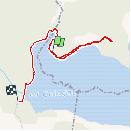
Charpal

Spinnaker
User

Length
3.6 km

Max alt
1340 m

Uphill gradient
36 m
Km-Effort
4.1 km

Min alt
1323 m

Downhill gradient
34 m
Boucle
No
Creation date :
2019-11-09 14:21:08.822
Updated on :
2019-11-09 15:13:19.053
51m
Difficulty : Very easy

FREE GPS app for hiking
 SityTrail
IGN / Geographical institutes
SityTrail Plus
The world is yours!
About
Trail Walking of 3.6 km to be discovered at Occitania, Lozère, Arzenc-de-Randon. This trail is proposed by Spinnaker.
Positioning
Country:
France
Region :
Occitania
Department/Province :
Lozère
Municipality :
Arzenc-de-Randon
Location:
Unknown
Start:(Dec)
Start:(UTM)
544886 ; 4941945 (31T) N.
Comments