


Viso1 J2v - Monte Granero (3170m)

patjobou
User
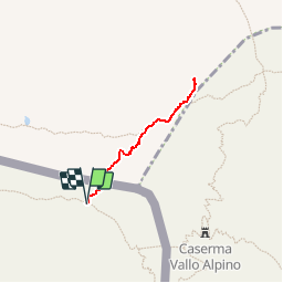

Length
1.3 km

Max alt
3131 m

Uphill gradient
217 m
Km-Effort
4.2 km

Min alt
2879 m

Downhill gradient
216 m
Boucle
Yes
Creation date :
2019-11-09 16:14:50.249
Updated on :
2019-11-10 20:44:40.946
46m
Difficulty : Easy

FREE GPS app for hiking
 SityTrail
IGN / Geographical institutes
SityTrail Plus
The world is yours!
About
Trail Walking of 1.3 km to be discovered at Provence-Alpes-Côte d'Azur, Hautes-Alpes, Abriès-Ristolas. This trail is proposed by patjobou.
Description
Tracé à l'écran.
Positioning
Country:
France
Region :
Provence-Alpes-Côte d'Azur
Department/Province :
Hautes-Alpes
Municipality :
Abriès-Ristolas
Location:
Ristolas
Start:(Dec)
Start:(UTM)
346603 ; 4952932 (32T) N.
Comments