Trail Walking Monoblet - Monoblet 10-2013 - Photo

Monoblet 10-2013

© OpenStreetMap contributors
Length
Length
12.1 km
Max alt
Max alt
461 m
Uphill gradient
Uphill gradient
342 m
Km-Effort
Km-Effort  
16.6 km
Min alt
Min alt
200 m
Downhill gradient
Downhill gradient
350 m
Boucle
Boucle
No
Creation date :
2015-05-22 00:00:00.0
Updated on :
2015-05-22 00:00:00.0

(1 Reviews)

Walking
Walking
3h34
Difficulty : Easy

Scan this QR Code to open this trail in the SityTrail application

FREE GPS app for hiking

Logo SityTrail SityTrail

IGN / Geographical institutes

Download SityTrail from the App Store Download SityTrail from Google Play

Logo SityTrail SityTrail World

The world is yours!

Download SityTrail from the App Store Download SityTrail from Google Play Download SityTrail on Huawei AppGallery

About

Trail Walking of 12.1 km to be discovered at Occitania, Gard, Monoblet. This trail is proposed by zoe.vienne.

Description

Y

Elevation profile

Positioning

Country:
France
Region :
Occitania
Department/Province :
Gard
Municipality :
Monoblet
Location:
Unknown
Start:(UTM)
571047 ; 4872283 (31T) N.

Comments

Please log in to post a review or rate the element


balade très sympa même si une bonne partie du circuit se fait sur routes goudronnées (cependant très étroites et bien ombragées )


Trails nearby

Trail Walking Sauve - Chateau de Freissac / le Crespou - Photo
Walking
GUIDE
nadinebondoux

Walking

Medium
Sauve, Occitania, Gard, France
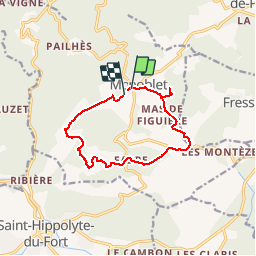
16.8 km | 23 km-effort
5h 40min
Yes
Trail On foot Colognac - 30 du Cayrel au Camp Barrat 20/02/24 - Photo
On foot
silvestreclaudine

On foot

Medium
Colognac, Occitania, Gard, France
16 km | 25 km-effort
5h 38min
Yes
Trail Walking Lasalle - Lasalle  - Photo
Walking
GUIDE
Roger Philippe Wallez

Walking

Very difficult
Lasalle, Occitania, Gard, France
15.3 km | 22 km-effort
10h 52min
No
Trail Walking Lasalle - LaSalle  - Photo
Walking
GUIDE
Roger Philippe Wallez

Walking

Very difficult
Lasalle, Occitania, Gard, France
15.3 km | 22 km-effort
5h 31min
No
Trail Walking Lasalle - vallée Salindrenque autour de Lasalle  - Photo
Walking
GUIDE
nadinebondoux

Walking

Medium
Lasalle, Occitania, Gard, France
13.3 km | 19.7 km-effort
5h 9min
Yes
Trail Road bike Saint-Hippolyte-du-Fort - St hippolyte Sumène  - Photo
Road bike
GUIDE
Roger Philippe Wallez

Road bike

Very difficult
Saint-Hippolyte-du-Fort, Occitania, Gard, France
46 km | 54 km-effort
3h 18min
Yes
Trail Walking Lasalle - Lasalle Briontet Soudorgues - Photo
Walking
GUIDE
nadinebondoux

Walking

Difficult
Lasalle, Occitania, Gard, France
17.9 km | 29 km-effort
5h 32min
Yes
Trail Walking Lasalle - LaSalle - Photo
Walking
GUIDE
Roger Philippe Wallez

Walking

Very difficult
Lasalle, Occitania, Gard, France
18.8 km | 30 km-effort
6h 29min
No
Trail Walking Saint-Hippolyte-du-Fort - 30  Roquefourcade 16-03_23 - Photo
Walking
silvestreclaudine

Walking

Very difficult
Saint-Hippolyte-du-Fort, Occitania, Gard, France
17.1 km | 24 km-effort
6h 37min
Yes


Close
My subscriptions