


Chausey

Glurps
User

Length
6.8 km

Max alt
20 m

Uphill gradient
77 m
Km-Effort
7.9 km

Min alt
0 m

Downhill gradient
80 m
Boucle
Yes
Creation date :
2019-11-10 09:31:44.0
Updated on :
2019-11-10 12:12:44.022
2h38
Difficulty : Difficult

FREE GPS app for hiking
 SityTrail
IGN / Geographical institutes
SityTrail Plus
The world is yours!
About
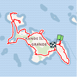
Trail Walking of 6.8 km to be discovered at Normandy, Manche, Granville. This trail is proposed by Glurps.
Description
Tour de Chausey à pied
Positioning
Country:
France
Region :
Normandy
Department/Province :
Manche
Municipality :
Granville
Location:
Unknown
Start:(Dec)
Start:(UTM)
586149 ; 5413935 (30U) N.
Comments