


SityTrail - Poix- marie gobaille- smuid

renneph
User
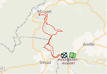

Length
15.7 km

Max alt
393 m

Uphill gradient
357 m
Km-Effort
20 km

Min alt
266 m

Downhill gradient
357 m
Boucle
Yes
Creation date :
2019-11-11 07:18:20.739
Updated on :
2020-02-08 18:56:52.711
3h07
Difficulty : Difficult

FREE GPS app for hiking
 SityTrail
IGN / Geographical institutes
SityTrail Plus
The world is yours!
About
Trail Walking of 15.7 km to be discovered at Wallonia, Luxembourg, Saint-Hubert. This trail is proposed by renneph.
Photos


Positioning
Country:
Belgium
Region :
Wallonia
Department/Province :
Luxembourg
Municipality :
Saint-Hubert
Location:
Hatrival
Start:(Dec)
Start:(UTM)
664285 ; 5543284 (31U) N.
Comments