


V 2019 Cluny Rando des Moines

clabidault
User
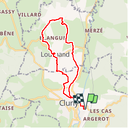

Length
14.6 km

Max alt
408 m

Uphill gradient
432 m
Km-Effort
20 km

Min alt
231 m

Downhill gradient
432 m
Boucle
Yes
Creation date :
2019-11-11 08:35:01.347
Updated on :
2019-11-11 17:35:24.961
4h27
Difficulty : Very easy

FREE GPS app for hiking
 SityTrail
IGN / Geographical institutes
SityTrail Plus
The world is yours!
About
Trail Walking of 14.6 km to be discovered at Bourgogne-Franche-Comté, Saône-et-Loire, Cluny. This trail is proposed by clabidault.
Positioning
Country:
France
Region :
Bourgogne-Franche-Comté
Department/Province :
Saône-et-Loire
Municipality :
Cluny
Location:
Unknown
Start:(Dec)
Start:(UTM)
628241 ; 5143243 (31T) N.
Comments